
Canduman topographic map
Interactive map
Click on the map to display elevation.
About this map
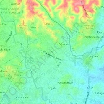
Name: Canduman topographic map, elevation, terrain.
Location: Canduman, Mandaue, Central Visayas, 6001, Philippines (10.34866 123.91398 10.38866 123.95398)
Average elevation: 121 ft
Minimum elevation: 3 ft
Maximum elevation: 358 ft
It is one of the two (the other one being the municipality of Consolacion) local government units located within the mainland Metro Cebu where the elevation of land is less than 100 m (330 ft).
Other topographic maps
Click on a map to view its topography, its elevation and its terrain.
Buagsong
Philippines > Mandaue > Buagsong
Buagsong, Mandaue, Central Visayas, 6014, Philippines
Average elevation: 16 ft