
Hogansville topographic map
Interactive map
Click on the map to display elevation.
About this map
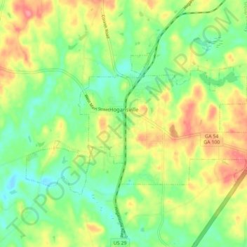
Name: Hogansville topographic map, elevation, terrain.
Location: Hogansville, Troup County, Georgia, United States (33.14820 -84.94935 33.18974 -84.86255)
Average elevation: 751 ft
Minimum elevation: 640 ft
Maximum elevation: 896 ft
Other topographic maps
Click on a map to view its topography, its elevation and its terrain.
LaGrange
United States > Georgia > Troup County
LaGrange, Troup County, Georgia, United States
Average elevation: 722 ft
West Point
United States > Georgia > Troup County
West Point, Troup County, Georgia, United States
Average elevation: 630 ft