
Chipinge topographic map
Interactive map
Click on the map to display elevation.
About this map
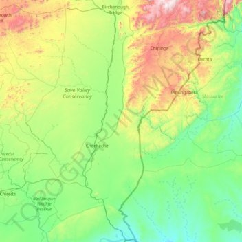
Name: Chipinge topographic map, elevation, terrain.
Location: Chipinge, Manicaland Province, Zimbabwe (-21.32857 32.13639 -19.90707 32.87554)
Average elevation: 1,749 ft
Minimum elevation: 486 ft
Maximum elevation: 6,385 ft
Pockets of mid-elevation evergreen forest occur on a few eastward-facing mountain slopes in the district, where the mountains create orographic precipitation from winds coming from the Indian Ocean.
Other topographic maps
Click on a map to view its topography, its elevation and its terrain.
Nyanga
Zimbabwe > Manicaland Province
Nyanga, Manicaland Province, Zimbabwe
Average elevation: 3,389 ft
Mutare
Zimbabwe > Manicaland Province
Mutare, Manicaland Province, Zimbabwe
Average elevation: 3,264 ft
Mutasa
Zimbabwe > Manicaland Province
Mutasa, Manicaland Province, Zimbabwe
Average elevation: 4,140 ft