
Andes Mountain topographic map
Interactive map
Click on the map to display elevation.
About this map
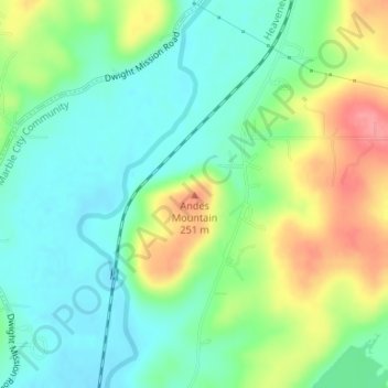
Name: Andes Mountain topographic map, elevation, terrain.
Average elevation: 663 ft
Minimum elevation: 564 ft
Maximum elevation: 843 ft
Other topographic maps
Click on a map to view its topography, its elevation and its terrain.
Box
United States > Oklahoma > Sequoyah County
Box, Sequoyah County, Oklahoma, United States
Average elevation: 883 ft
Brushy
United States > Oklahoma > Sequoyah County
Brushy, Sequoyah County, Oklahoma, United States
Average elevation: 883 ft
Marble City
United States > Oklahoma > Sequoyah County
Marble City, Sequoyah County, Oklahoma, United States
Average elevation: 699 ft
Gore
United States > Oklahoma > Sequoyah County
Gore, Sequoyah County, Oklahoma, 74435, United States
Average elevation: 545 ft
Short
United States > Oklahoma > Sequoyah County
Short, Sequoyah County, Oklahoma, United States
Average elevation: 725 ft
McKey
United States > Oklahoma > Sequoyah County
McKey, Sequoyah County, Oklahoma, United States
Average elevation: 574 ft
Carlisle
United States > Oklahoma > Sequoyah County
Carlisle, Sequoyah County, Oklahoma, United States
Average elevation: 620 ft
Roland
United States > Oklahoma > Sequoyah County
Roland, Sequoyah County, Oklahoma, 74954, United States
Average elevation: 509 ft
Sallisaw
United States > Oklahoma > Sequoyah County
Sallisaw, Sequoyah County, Oklahoma, 74955, United States
Average elevation: 548 ft
Muldrow
United States > Oklahoma > Sequoyah County
Muldrow, Sequoyah County, Oklahoma, 74948, United States
Average elevation: 538 ft
Paradise Hill
United States > Oklahoma > Sequoyah County > Paradise Hill
Paradise Hill, Sequoyah County, Oklahoma, United States
Average elevation: 725 ft