
Montseny topographic map
Interactive map
Click on the map to display elevation.
About this map
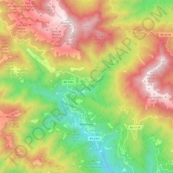
Name: Montseny topographic map, elevation, terrain.
Location: Montseny, Vallès Oriental, Barcelona, Catalonia, 08469, Spain (41.74563 2.33409 41.80871 2.44395)
Average elevation: 3,258 ft
Minimum elevation: 1,053 ft
Maximum elevation: 5,554 ft
Other topographic maps
Click on a map to view its topography, its elevation and its terrain.
Vilardell
Spain > Catalonia > Vallès Oriental > Sant Celoni > Sant Celoni > Vilardell
Vilardell, Sant Celoni, Vallès Oriental, Barcelona, Catalonia, 08470, Spain
Average elevation: 630 ft