
Evolène topographic map
Interactive map
Click on the map to display elevation.
About this map
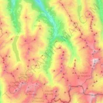
Name: Evolène topographic map, elevation, terrain.
Location: Evolène, Hérens, Wallis, 1983, Switzerland (45.95490 7.42553 46.14706 7.61195)
Average elevation: 8,848 ft
Minimum elevation: 3,704 ft
Maximum elevation: 14,272 ft
At precisely 8.27 pm, the first two avalanches were set off on the slopes above Villa, at an altitude around 2,600 m (8,500 ft). They were a combination of fresh powder snow and established spring snow and demolished all trees and chalets in their path, as well as the people unlucky enough to be in the chalets at the time. The two avalanches continued to run along the extremities of Villa and eventually formed as one massive fusion of snow and debris reaching up to 15 m (49 ft) high that came to rest 1,000 m (3,300 ft) down the slope, after taking 12 lives and cutting off the main road between Evolène and des Haudères.
Other topographic maps
Click on a map to view its topography, its elevation and its terrain.
Mont-Noble
Switzerland > Wallis > Hérens
Mont-Noble, Hérens, Wallis, 1973, Switzerland
Average elevation: 5,436 ft