
Mount Agung topographic map
Interactive map
Click on the map to display elevation.
About this map
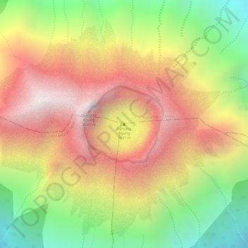
Name: Mount Agung topographic map, elevation, terrain.
Location: Mount Agung, Kecamatan Bebandem, Karangasem, Bali, Indonesia (-8.34294 115.50716 -8.34284 115.50726)
Average elevation: 8,314 ft
Minimum elevation: 6,398 ft
Maximum elevation: 9,875 ft
Other topographic maps
Click on a map to view its topography, its elevation and its terrain.
Kecamatan Karangasem
Indonesia > Bali > Karangasem > Amlapura
Kecamatan Karangasem, Amlapura, Kecamatan Karangasem, Karangasem, Bali, Lesser Sunda Islands, Indonesia
Average elevation: 568 ft