
Serra de Água topographic map
Interactive map
Click on the map to display elevation.
About this map
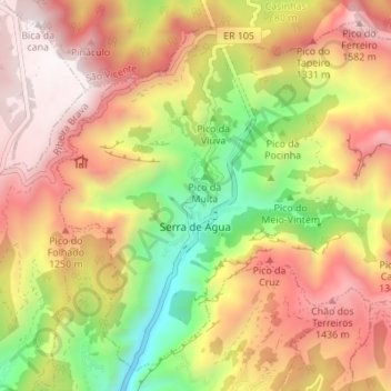
Name: Serra de Água topographic map, elevation, terrain.
Location: Serra de Água, Ribeira Brava, Madeira, Portugal (32.70493 -17.05195 32.75663 -16.98342)
Average elevation: 3,104 ft
Minimum elevation: 568 ft
Maximum elevation: 5,302 ft
Other topographic maps
Click on a map to view its topography, its elevation and its terrain.
São Paulo
Portugal > Ribeira Brava > São Paulo
São Paulo, Ribeira Brava, Madeira, 9350-042, Portugal
Average elevation: 2,182 ft