
Chattahoochee County topographic map
Interactive map
Click on the map to display elevation.
About this map
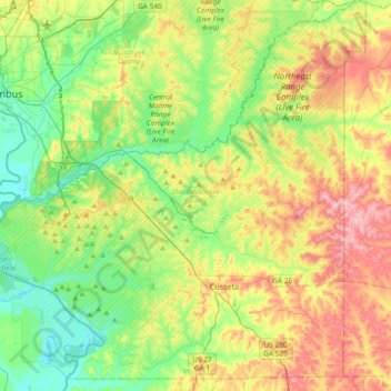
Name: Chattahoochee County topographic map, elevation, terrain.
Location: Chattahoochee County, Georgia, United States (32.22083 -85.00730 32.53621 -84.63729)
Average elevation: 404 ft
Minimum elevation: 187 ft
Maximum elevation: 761 ft
Other topographic maps
Click on a map to view its topography, its elevation and its terrain.
Fort Benning
United States > Georgia > Chattahoochee County > Chattahoochee County
Fort Benning, Chattahoochee County, Georgia, 31905, United States
Average elevation: 312 ft
Cusseta
United States > Georgia > Chattahoochee County
Cusseta, Chattahoochee County, Georgia, United States
Average elevation: 469 ft
Montgomery Hill
United States > Georgia > Chattahoochee County > Chattahoochee County
Montgomery Hill, Chattahoochee County, Georgia, United States
Average elevation: 315 ft