
Comblain-au-Pont topographic map
Interactive map
Click on the map to display elevation.
About this map
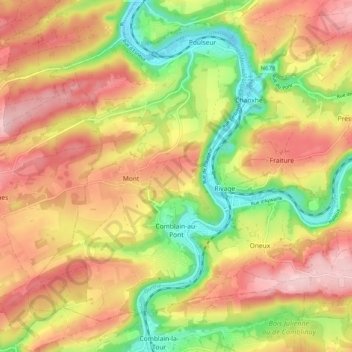
Name: Comblain-au-Pont topographic map, elevation, terrain.
Location: Comblain-au-Pont, Liège, Wallonia, Belgium (50.45917 5.53532 50.51183 5.63567)
Average elevation: 656 ft
Minimum elevation: 285 ft
Maximum elevation: 978 ft
Other topographic maps
Click on a map to view its topography, its elevation and its terrain.
Rotheux-Rimière
Belgium > Liège > Liège > Rotheux-Rimière
Rotheux-Rimière, Neupré, Liège, Wallonia, 4120, Belgium
Average elevation: 764 ft
La Corniche
Belgium > Liège > Liège > Esneux
La Corniche, Esneux, Liège, Wallonia, 4130, Belgium
Average elevation: 512 ft
Chaudfontaine
Chaudfontaine, Liège, Wallonia, 4050, Belgium
Average elevation: 617 ft