
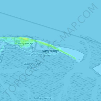
Wangerooge topographic map
Interactive map
Click on the map to display elevation.
About this map
Name: Wangerooge topographic map, elevation, terrain.
Location: Wangerooge, Landkreis Friesland, Lower Saxony, 26486, Germany (53.77231 7.84662 53.79456 7.97848)
Average elevation: 0 ft
Minimum elevation: -13 ft
Maximum elevation: 36 ft
Wangerooge is a German island in the southern North Sea and is the easternmost of the seven inhabited East Frisian islands. The island stretches over 8.5 kilometers in length in the east-west direction. The north-south extension is a maximum of 2.2 kilometers in the western part, and 1.2 kilometers at the level of the village. The distance to the main land is 7 kilometers. To the west of Wangerooge, which is separated by the Gat of Harle, the eastern Spiekeroog is 2 kilometers away. Separated by the Blaue Balje, the island Minsener Oog begins, which is 2 kilometers east-southeast. On the northside, there is a sandy beach that is about 100 meters wide and 3 kilometers long. In the east, this beach merges into a 500 meter wide and 3 kilometer long field with sand deposits. In the west of the island, there are two more beaches that are ½ kilometer and 1 kilometer in length. To the south of the island lies the Wadden Sea, which is part of the Lower Saxon Wadden Sea National Park, like the islands, and is very dry at Baseflow. Below the island, at a depth of about 15 meters, there is the Geest base. The highest elevation of the island is the look-out dune, which is 17 meters above sea level. The remaining sand dunes reach heights of up to 12 meters.