
Beni Mered topographic map
Interactive map
Click on the map to display elevation.
About this map
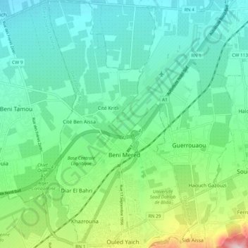
Name: Beni Mered topographic map, elevation, terrain.
Location: Beni Mered, Ouled Yaich District, Blida, 09130, Algeria (36.49510 2.83276 36.57052 2.87715)
Average elevation: 400 ft
Minimum elevation: 128 ft
Maximum elevation: 1,270 ft
Other topographic maps
Click on a map to view its topography, its elevation and its terrain.
Chrea
Algeria > Blida > Ouled Yaich District > Chrea
Chrea, Ouled Yaich District, Blida, Algeria
Average elevation: 4,242 ft