
Chur topographic map
Interactive map
Click on the map to display elevation.
About this map
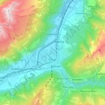
Name: Chur topographic map, elevation, terrain.
Location: Chur, Plessur, Grisons, Switzerland (46.81803 9.45411 46.90424 9.59524)
Average elevation: 3,862 ft
Minimum elevation: 1,755 ft
Maximum elevation: 9,160 ft
The altitude in the city area varies from 600 meters (2,000 ft) above sea level to 1,800 meters (5,900 ft) above sea level, the Churer Hausberg Brambrüesch (accessible from the Old Town) situated at 2,174 meters (7,133 ft) above sea level.
Other topographic maps
Click on a map to view its topography, its elevation and its terrain.