
Levent Mahallesi topographic map
Interactive map
Click on the map to display elevation.
About this map
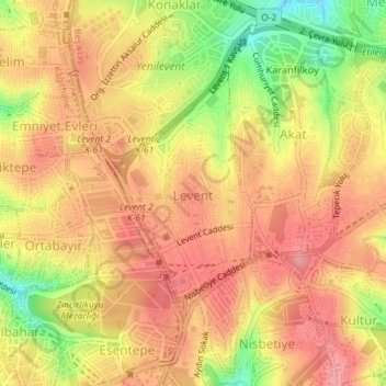
Name: Levent Mahallesi topographic map, elevation, terrain.
Average elevation: 374 ft
Minimum elevation: 141 ft
Maximum elevation: 505 ft
Other topographic maps
Click on a map to view its topography, its elevation and its terrain.
Bebek Parkı
Bebek Parkı, Bebek Mahallesi, Beşiktaş, Istanbul, Marmara Region, 34342, Turkey
Average elevation: 207 ft
Bebek Çınarlı Bahçe Parkı
Bebek Çınarlı Bahçe Parkı, Bebek Mahallesi, Beşiktaş, Istanbul, Marmara Region, 34342, Turkey
Average elevation: 213 ft
Etiler Mahallesi
Etiler Mahallesi, Beşiktaş, Istanbul, Marmara Region, 34337, Turkey
Average elevation: 269 ft