
Mutare topographic map
Interactive map
Click on the map to display elevation.
About this map
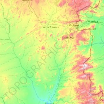
Name: Mutare topographic map, elevation, terrain.
Location: Mutare, Manicaland Province, Zimbabwe (-19.77875 32.01407 -18.71876 32.87753)
Average elevation: 3,264 ft
Minimum elevation: 1,680 ft
Maximum elevation: 7,434 ft
The Eastern Highlands extend north and south through eastern portion of the district, along the border with Mozambique. The Bvumba Mountains form a part of the highlands, and rise southeast of Mutare city. The highest peak is Castle Beacon at 1,911 metres. The Bunga Forest Botanical Reserve conserves the mountains' high-elevation mist forest. Banti Forest Reserve (22.2 km²) is located south of the Bvumba Range, in the mountains along the Mozambican border.
Other topographic maps
Click on a map to view its topography, its elevation and its terrain.
Nyanga
Zimbabwe > Manicaland Province
Nyanga, Manicaland Province, Zimbabwe
Average elevation: 3,389 ft
Chipinge
Zimbabwe > Manicaland Province
Chipinge, Manicaland Province, Zimbabwe
Average elevation: 1,749 ft
Mutasa
Zimbabwe > Manicaland Province
Mutasa, Manicaland Province, Zimbabwe
Average elevation: 4,140 ft