
Caldicot topographic map
Interactive map
Click on the map to display elevation.
About this map
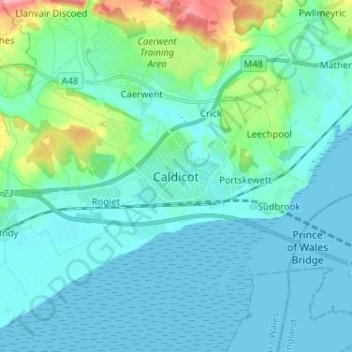
Name: Caldicot topographic map, elevation, terrain.
Location: Caldicot, Monmouthshire, Wales, NP26 4BW, United Kingdom (51.55125 -2.79176 51.63125 -2.71176)
Average elevation: 69 ft
Minimum elevation: 0 ft
Maximum elevation: 440 ft
Other topographic maps
Click on a map to view its topography, its elevation and its terrain.
Crick
United Kingdom > Wales > Monmouthshire
Crick, Monmouthshire, Wales, NP26 5UW, United Kingdom
Average elevation: 95 ft
Raglan
United Kingdom > Wales > Monmouthshire
Raglan, Monmouthshire, Wales, NP15 2DR, United Kingdom
Average elevation: 197 ft
Abergavenny
United Kingdom > Wales > Monmouthshire
Abergavenny, Monmouthshire, Wales, NP7 5NQ, United Kingdom
Average elevation: 614 ft