
Khenifra topographic map
Interactive map
Click on the map to display elevation.
About this map
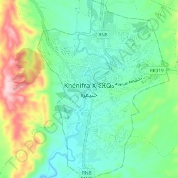
Name: Khenifra topographic map, elevation, terrain.
Average elevation: 2,927 ft
Minimum elevation: 2,648 ft
Maximum elevation: 3,615 ft
Other topographic maps
Click on a map to view its topography, its elevation and its terrain.
Khenifra
Morocco > Pachalik de Khenifra > Khenifra
Khenifra, Pachalik de Khenifra, Khénifra Province, Béni Mellal-Khénifra, 54024, Morocco
Average elevation: 3,307 ft