
Cowes topographic map
Interactive map
Click on the map to display elevation.
About this map
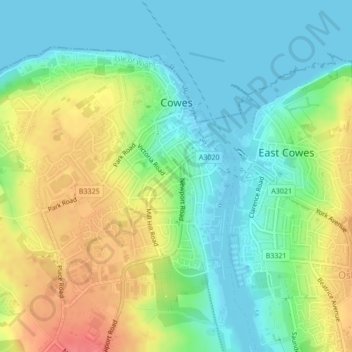
Name: Cowes topographic map, elevation, terrain.
Location: Cowes, Isle of Wight, England, United Kingdom (50.74769 -1.32105 50.76756 -1.29143)
Average elevation: 82 ft
Minimum elevation: 0 ft
Maximum elevation: 213 ft
Other topographic maps
Click on a map to view its topography, its elevation and its terrain.
Sandown
United Kingdom > England > Isle of Wight
Sandown, Isle of Wight, England, United Kingdom
Average elevation: 59 ft
Norton Vale
United Kingdom > England > Isle of Wight > Shanklin
Norton Vale, Lower Hyde, Shanklin, Isle of Wight, England, United Kingdom
Average elevation: 154 ft
Newport
United Kingdom > England > Isle of Wight
Newport, Isle of Wight, England, United Kingdom
Average elevation: 180 ft
Ventnor
United Kingdom > England > Isle of Wight
Ventnor, Isle of Wight, England, United Kingdom
Average elevation: 190 ft
Totland
United Kingdom > England > Isle of Wight > Colwell Bay
Totland, Colwell Bay, Isle of Wight, South East England, England, PO40 9NP, United Kingdom
Average elevation: 52 ft
Isle of Wight
United Kingdom > England > Isle of Wight
Isle of Wight, England, United Kingdom
Average elevation: 56 ft
Ryde
United Kingdom > England > Isle of Wight
Ryde, Isle of Wight, England, United Kingdom
Average elevation: 69 ft