
Molina topographic map
Interactive map
Click on the map to display elevation.
About this map
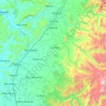
Name: Molina topographic map, elevation, terrain.
Location: Molina, Provincia de Curicó, Maule Region, Chile (-35.63041 -71.50302 -35.02723 -70.38652)
Average elevation: 2,195 ft
Minimum elevation: 79 ft
Maximum elevation: 12,927 ft
Other topographic maps
Click on a map to view its topography, its elevation and its terrain.
Guaico Tres
Chile > Maule Region > Provincia de Curicó > Romeral
Guaico Tres, Romeral, Provincia de Curicó, Maule Region, Chile
Average elevation: 1,473 ft
Vichuquén
Chile > Maule Region > Provincia de Curicó
Vichuquén, Provincia de Curicó, Maule Region, Chile
Average elevation: 427 ft
Curicó
Chile > Maule Region > Provincia de Curicó
Curicó, Provincia de Curicó, Maule Region, Chile
Average elevation: 2,159 ft