
Harrodsburg topographic map
Interactive map
Click on the map to display elevation.
About this map
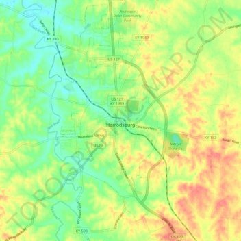
Name: Harrodsburg topographic map, elevation, terrain.
Location: Harrodsburg, Mercer County, Kentucky, 40330, United States (37.71946 -84.87667 37.80812 -84.81590)
Average elevation: 889 ft
Minimum elevation: 801 ft
Maximum elevation: 994 ft
Other topographic maps
Click on a map to view its topography, its elevation and its terrain.
Nevada
United States > Kentucky > Mercer County
Nevada, Mercer County, Kentucky, United States
Average elevation: 879 ft
Harrodsburg
United States > Kentucky > Mercer County > Harrodsburg > Harrodsburg
Harrodsburg, Mercer County, Kentucky, 40330, United States
Average elevation: 889 ft