
Sevastopol topographic map
Interactive map
Click on the map to display elevation.
About this map
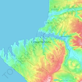
Name: Sevastopol topographic map, elevation, terrain.
Location: Sevastopol, 99001, Ukraine (44.51225 33.37796 44.70140 33.61062)
Average elevation: 190 ft
Minimum elevation: -7 ft
Maximum elevation: 945 ft
Other topographic maps
Click on a map to view its topography, its elevation and its terrain.
Balaklava
Ukraine > Sevastopol > Балаклавский округ > Balaklava
Balaklava, Балаклавский округ, Балаклавский район, Sevastopol, Ukraine
Average elevation: 305 ft