
Bourg-Saint-Pierre topographic map
Interactive map
Click on the map to display elevation.
About this map
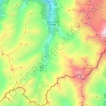
Name: Bourg-Saint-Pierre topographic map, elevation, terrain.
Location: Bourg-Saint-Pierre, Entremont, Valais/Wallis, 1946, Switzerland (45.85868 7.13761 45.97421 7.30085)
Average elevation: 8,301 ft
Minimum elevation: 4,731 ft
Maximum elevation: 13,619 ft
Other topographic maps
Click on a map to view its topography, its elevation and its terrain.
Glacier de Corbassière
Switzerland > Valais/Wallis > Bourg-Saint-Pierre
Glacier de Corbassière, Spalla Isler, Bourg-Saint-Pierre, Entremont, Valais/Wallis, 1946, Switzerland
Average elevation: 9,646 ft
Great St Bernard Pass
Switzerland > Valais/Wallis > Bourg-Saint-Pierre
Great St Bernard Pass, 21, Bourg-Saint-Pierre, Entremont, Valais/Wallis, 1946, Switzerland
Average elevation: 8,117 ft