
Achrol topographic map
Interactive map
Click on the map to display elevation.
About this map
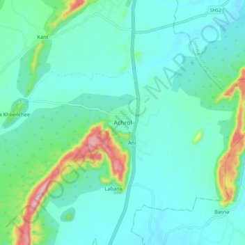
Name: Achrol topographic map, elevation, terrain.
Location: Achrol, Amber Tehsil, Jaipur, Rajasthan, 303002, India (27.09321 75.91663 27.17321 75.99663)
Average elevation: 1,483 ft
Minimum elevation: 1,329 ft
Maximum elevation: 2,146 ft
Other topographic maps
Click on a map to view its topography, its elevation and its terrain.
Amber
India > Rajasthan > Amber Tehsil > Jaipur Municipal Corporation
Amber, Jaipur Municipal Corporation, Amber Tehsil, Jaipur District, Rajasthan, 303101, India
Average elevation: 1,535 ft