
Kingston topographic map
Interactive map
Click on the map to display elevation.
About this map
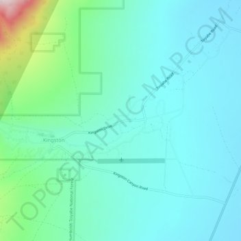
Name: Kingston topographic map, elevation, terrain.
Location: Kingston, Lander County, Nevada, United States (39.18597 -117.10926 39.22597 -117.06926)
Average elevation: 6,444 ft
Minimum elevation: 5,853 ft
Maximum elevation: 8,409 ft
Other topographic maps
Click on a map to view its topography, its elevation and its terrain.
Austin
United States > Nevada > Lander County
Austin, Lander County, Nevada, United States
Average elevation: 6,811 ft
Battle Mountain
United States > Nevada > Lander County
Battle Mountain, Lander County, Nevada, United States
Average elevation: 4,514 ft