
St. Pauli topographic map
Interactive map
Click on the map to display elevation.
About this map
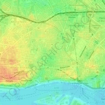
Name: St. Pauli topographic map, elevation, terrain.
Location: St. Pauli, Hamburg-Mitte, Hamburg, Germany (53.54317 9.95497 53.56380 9.99029)
Average elevation: 62 ft
Minimum elevation: 0 ft
Maximum elevation: 125 ft
Other topographic maps
Click on a map to view its topography, its elevation and its terrain.
21037
Germany > Hamburg > Fünfhausen
21037, Bergedorf, Fünfhausen, Hamburg, Germany
Average elevation: 10 ft