
Le Tampon topographic map
Interactive map
Click on the map to display elevation.
About this map
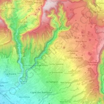
Name: Le Tampon topographic map, elevation, terrain.
Location: Le Tampon, Saint-Pierre, Réunion, France (-21.31661 55.47953 -21.13358 55.66070)
Average elevation: 3,297 ft
Minimum elevation: 72 ft
Maximum elevation: 7,694 ft
Other topographic maps
Click on a map to view its topography, its elevation and its terrain.
Bras de Pontho
Bras de Pontho, Le Tampon, Saint-Pierre, Réunion, 97414, France
Average elevation: 1,965 ft