
Waterloo topographic map
Interactive map
Click on the map to display elevation.
About this map
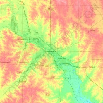
Name: Waterloo topographic map, elevation, terrain.
Location: Waterloo, Black Hawk County, Iowa, 50701-1334, United States (42.33828 -92.49287 42.65828 -92.17287)
Average elevation: 925 ft
Minimum elevation: 794 ft
Maximum elevation: 1,040 ft
The average elevation of Waterloo is 846 feet above sea level. The population density is 1101 people per square mile, considered low for an urban area.