
Wellsburg topographic map
Interactive map
Click on the map to display elevation.
About this map
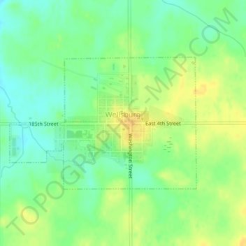
Name: Wellsburg topographic map, elevation, terrain.
Location: Wellsburg, Grundy County, Iowa, United States (42.42684 -92.94318 42.44132 -92.91541)
Average elevation: 1,073 ft
Minimum elevation: 1,027 ft
Maximum elevation: 1,115 ft
Other topographic maps
Click on a map to view its topography, its elevation and its terrain.
Grundy Center
United States > Iowa > Grundy County
Grundy Center, Grundy County, Iowa, United States
Average elevation: 1,004 ft
Dike
United States > Iowa > Grundy County
Dike, Grundy County, Iowa, United States
Average elevation: 955 ft
Beaman
United States > Iowa > Grundy County
Beaman, Grundy County, Iowa, United States
Average elevation: 1,014 ft
Holland
United States > Iowa > Grundy County
Holland, Grundy County, Iowa, United States
Average elevation: 1,017 ft
Reinbeck
United States > Iowa > Grundy County
Reinbeck, Grundy County, Iowa, 50669, United States
Average elevation: 951 ft
Conrad
United States > Iowa > Grundy County
Conrad, Grundy County, Iowa, 50621, United States
Average elevation: 1,027 ft
Stout
United States > Iowa > Grundy County
Stout, Grundy County, Iowa, 50673, United States
Average elevation: 1,014 ft
Morrison
United States > Iowa > Grundy County
Morrison, Grundy County, Iowa, 50657, United States
Average elevation: 968 ft