
Irinjalakuda topographic map
Interactive map
Click on the map to display elevation.
About this map
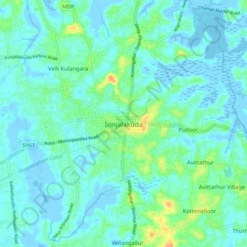
Name: Irinjalakuda topographic map, elevation, terrain.
Location: Irinjalakuda, Mukundapuram, Thrissur, Kerala, 680100, India (10.30544 76.17581 10.38544 76.25581)
Average elevation: 23 ft
Minimum elevation: -20 ft
Maximum elevation: 108 ft
Other topographic maps
Click on a map to view its topography, its elevation and its terrain.
Velli Kulangara
India > Kerala > Mukundapuram
Velli Kulangara, Mukundapuram, Thrissur District, Kerala, 680125, India
Average elevation: 26 ft
Karingachira
India > Kerala > Mukundapuram > Puthenchira
Karingachira, Puthenchira, Mukundapuram, Thrissur District, Kerala, India
Average elevation: 20 ft
Konathukunnu
India > Kerala > Mukundapuram
Konathukunnu, Mukundapuram, Thrissur District, Kerala, 680123, India
Average elevation: 30 ft
Thalore
India > Kerala > Mukundapuram > Thalore
Thalore, Mukundapuram, Thrissur district, Kerala, 680313, India
Average elevation: 39 ft