
Ponferrada topographic map
Interactive map
Click on the map to display elevation.
About this map
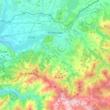
Name: Ponferrada topographic map, elevation, terrain.
Location: Ponferrada, El Bierzo, León, Castile and León, Spain (42.38622 -6.71411 42.61270 -6.40717)
Average elevation: 2,897 ft
Minimum elevation: 1,391 ft
Maximum elevation: 7,008 ft
Other topographic maps
Click on a map to view its topography, its elevation and its terrain.
A Corona
Spain > Castile and León > El Bierzo > Candín
A Corona, Candín, El Bierzo, León, Castile and León, 24433, Spain
Average elevation: 3,232 ft
Los Polines
Spain > Castile and León > El Bierzo > Noceda del Bierzo
Los Polines, Noceda del Bierzo, El Bierzo, León, Castile and León, 24319, Spain
Average elevation: 2,953 ft