
Bushehr topographic map
Interactive map
Click on the map to display elevation.
About this map
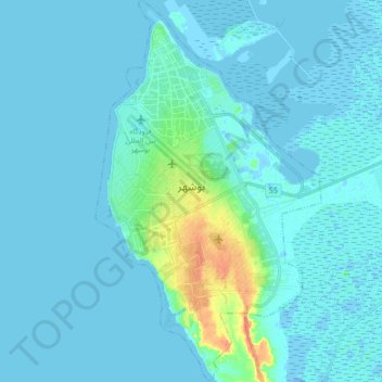
Name: Bushehr topographic map, elevation, terrain.
Average elevation: 16 ft
Minimum elevation: -56 ft
Maximum elevation: 141 ft
Other topographic maps
Click on a map to view its topography, its elevation and its terrain.
دهستان حومه بوشهر
Iran > Bushehr Province > Bushehr County > دهستان حومه بوشهر
دهستان حومه بوشهر, Bakhsh-e-Markazi of Bushehr County, Bushehr County, Bushehr Province, 75177-65941, Iran
Average elevation: 3 ft