
Ashland City topographic map
Interactive map
Click on the map to display elevation.
About this map
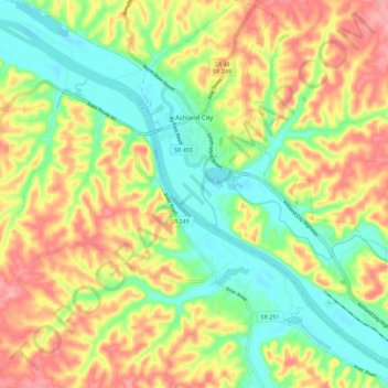
Name: Ashland City topographic map, elevation, terrain.
Average elevation: 545 ft
Minimum elevation: 367 ft
Maximum elevation: 758 ft
Other topographic maps
Click on a map to view its topography, its elevation and its terrain.
Kingston Springs
United States > Tennessee > Cheatham County
Kingston Springs, Cheatham County, Middle Tennessee, Tennessee, 37082, United States
Average elevation: 610 ft
Fox Bluff
United States > Tennessee > Cheatham County
Fox Bluff, Cheatham County, Middle Tennessee, Tennessee, United States
Average elevation: 499 ft
Pegram
United States > Tennessee > Cheatham County
Pegram, Cheatham County, Middle Tennessee, Tennessee, 37143, United States
Average elevation: 640 ft
Marrowbone
United States > Tennessee > Cheatham County > Marrowbone
Marrowbone, Cheatham County, Tennessee, United States
Average elevation: 548 ft
Craig Lake Dam
United States > Tennessee > Cheatham County
Craig Lake Dam, Cheatham County, Tennessee, 37062:37082, United States
Average elevation: 636 ft
Pleasant View
United States > Tennessee > Cheatham County
Pleasant View, Cheatham County, Middle Tennessee, Tennessee, 37146, United States
Average elevation: 669 ft