
Dr Ruth Segomotsi Mompati District Municipality topographic map
Interactive map
Click on the map to display elevation.
About this map
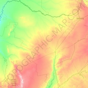
Name: Dr Ruth Segomotsi Mompati District Municipality topographic map, elevation, terrain.
Average elevation: 4,049 ft
Minimum elevation: 3,202 ft
Maximum elevation: 6,083 ft
Other topographic maps
Click on a map to view its topography, its elevation and its terrain.
Rustenburg Local Municipality
RSA > North West > Rustenburg Local Municipality
Rustenburg Local Municipality, Bojanala Platinum District Municipality, North West, 0322, RSA
Average elevation: 4,222 ft
Brits
RSA > North West > Brits
Brits, Bojanala Platinum District Municipality, North West, 0250, RSA
Average elevation: 3,675 ft
Tlokwe Ward 2
RSA > North West > Tlokwe Local Municipality
Tlokwe Ward 2, Tlokwe Local Municipality, Dr Kenneth Kaunda District Municipality, North West, 2191, RSA
Average elevation: 4,678 ft
Brooksby
RSA > North West > Brooksby
Brooksby, Ngaka Modiri Molema District Municipality, North West, RSA
Average elevation: 4,518 ft