
Sorong topographic map
Interactive map
Click on the map to display elevation.
About this map
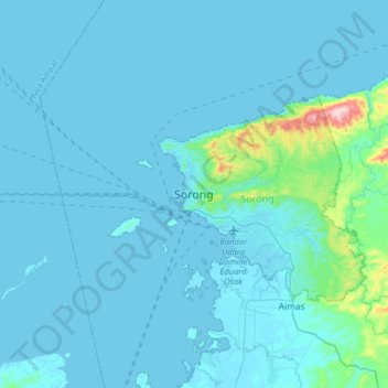
Name: Sorong topographic map, elevation, terrain.
Location: Sorong, West Papua, Indonesia (-1.02341 131.09448 -0.70341 131.41448)
Average elevation: 85 ft
Minimum elevation: -7 ft
Maximum elevation: 1,375 ft
Other topographic maps
Click on a map to view its topography, its elevation and its terrain.
Pulau Salawati
Indonesia > West Papua > Sorong
Pulau Salawati, Sorong, West Papua, Indonesia
Average elevation: 141 ft