
Trenton topographic map
Interactive map
Click on the map to display elevation.
About this map
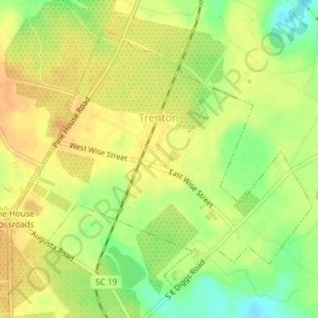
Name: Trenton topographic map, elevation, terrain.
Location: Trenton, Edgefield County, South Carolina, United States (33.72943 -81.85542 33.75157 -81.82493)
Average elevation: 610 ft
Minimum elevation: 541 ft
Maximum elevation: 650 ft
Other topographic maps
Click on a map to view its topography, its elevation and its terrain.
Colliers
United States > South Carolina > Edgefield County
Colliers, Edgefield County, South Carolina, United States
Average elevation: 374 ft