
The Borough District of Drogheda topographic map
Interactive map
Click on the map to display elevation.
About this map
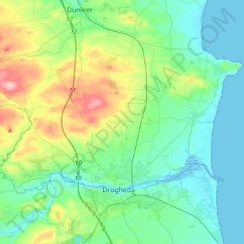
Name: The Borough District of Drogheda topographic map, elevation, terrain.
Average elevation: 164 ft
Minimum elevation: -3 ft
Maximum elevation: 686 ft
Other topographic maps
Click on a map to view its topography, its elevation and its terrain.
White River
White River, Dunleer ED, The Municipal District of Ardee, County Louth, Leinster, A92 RP77, Ireland
Average elevation: 246 ft
Termonfeckin
Termonfeckin, Termonfeckin ED, The Borough District of Drogheda, County Louth, Leinster, Ireland
Average elevation: 52 ft
Collon
Collon, Collon ED, The Municipal District of Ardee, County Louth, Leinster, Ireland
Average elevation: 466 ft
Drumlin ( E.D. Dunleer)
Drumlin ( E.D. Dunleer), Dunleer ED, The Municipal District of Ardee, County Louth, Leinster, Ireland
Average elevation: 161 ft
Greatwood
Greatwood, Clonkeen ED, The Municipal District of Ardee, County Louth, Leinster, Ireland
Average elevation: 131 ft
Dundalk
Ireland > County Louth > Dundalk
Dundalk, The Municipal District of Dundalk, County Louth, Leinster, A91 RC44, Ireland
Average elevation: 52 ft