
Hanna Lake topographic map
Interactive map
Click on the map to display elevation.
About this map
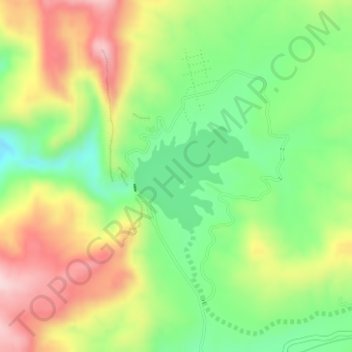
Name: Hanna Lake topographic map, elevation, terrain.
Location: Hanna Lake, Quetta, Balochistan, 87300, Pakistan (30.25173 67.09589 30.26013 67.10609)
Average elevation: 6,421 ft
Minimum elevation: 5,988 ft
Maximum elevation: 6,959 ft
Other topographic maps
Click on a map to view its topography, its elevation and its terrain.
Ziarat Park
Pakistan > Balochistan > Quetta
Ziarat Park, Habib Kili, Quetta, Balochistan, 87300, Pakistan
Average elevation: 5,505 ft