
Sinaia topographic map
Interactive map
Click on the map to display elevation.
About this map
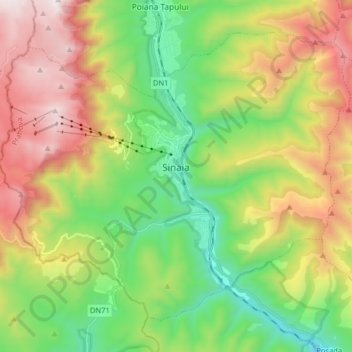
Name: Sinaia topographic map, elevation, terrain.
Location: Sinaia, Prahova, 106100, Romania (45.29640 25.46770 45.38861 25.62769)
Average elevation: 4,098 ft
Minimum elevation: 2,123 ft
Maximum elevation: 7,028 ft
Sinaia is about 65 kilometres (40 miles) northwest of Ploiești and 48 kilometres (30 miles) south of Brașov, in a mountainous area on the Prahova River valley, just east of the Bucegi Mountains. The town's altitude varies between 767 to 860 metres (2,516 to 2,822 feet) above sea level.
Other topographic maps
Click on a map to view its topography, its elevation and its terrain.
Valea Mantei
Romania > Prahova > Valea Mantei
Valea Mantei, Valea Călugărească, Prahova, 107631, Romania
Average elevation: 755 ft
Valea Călugărească
Romania > Prahova > Valea Călugărească
Valea Călugărească, Prahova, Romania
Average elevation: 505 ft