
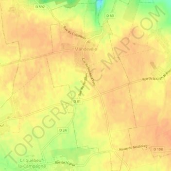
Mandeville topographic map
Interactive map
Click on the map to display elevation.
About this map
Name: Mandeville topographic map, elevation, terrain.
Average elevation: 515 ft
Minimum elevation: 423 ft
Maximum elevation: 541 ft
Other topographic maps
Click on a map to view its topography, its elevation and its terrain.
Les Andelys
Les Andelys, Eure, Normandy, Metropolitan France, 27700, France
Average elevation: 328 ft
Tillières-sur-Avre
Tillières-sur-Avre, Bernay, Eure, Normandy, Metropolitan France, 27570, France
Average elevation: 541 ft
Ivry-la-Bataille
Ivry-la-Bataille, Évreux, Eure, Normandy, Metropolitan France, 27540, France
Average elevation: 289 ft
Vexin-sur-Epte
Vexin-sur-Epte, Les Andelys, Eure, Normandy, Metropolitan France, 27630, France
Average elevation: 364 ft
Tourny
France > Normandy > Eure > Vexin-sur-Epte
Tourny, Vexin-sur-Epte, Les Andelys, Eure, Normandy, Metropolitan France, 27510, France
Average elevation: 430 ft
Le Thuit-de-l'Oison
Le Thuit-de-l'Oison, Bernay, Eure, Normandy, Metropolitan France, 27370, France
Average elevation: 459 ft
Romilly-sur-Andelle
Romilly-sur-Andelle, Les Andelys, Eure, Normandy, Metropolitan France, 27610, France
Average elevation: 262 ft
Le Val d'Hazey
Le Val d'Hazey, Les Andelys, Eure, Normandy, Metropolitan France, 27940, France
Average elevation: 266 ft
Saint-Pierre-de-Bailleul
Saint-Pierre-de-Bailleul, Les Andelys, Eure, Normandy, Metropolitan France, 27920, France
Average elevation: 328 ft
Les Bruyères
France > Normandy > Eure > Brosville
Les Bruyères, Brosville, Bernay, Eure, Normandy, Metropolitan France, 27930, France
Average elevation: 335 ft
La Chapelle-Gauthier
La Chapelle-Gauthier, Bernay, Eure, Normandy, Metropolitan France, 27270, France
Average elevation: 623 ft
Port-Morin
France > Normandy > Eure > Les Trois Lacs
Port-Morin, Tosny, Les Trois Lacs, Les Andelys, Eure, Normandy, Metropolitan France, 27700, France
Average elevation: 207 ft
Gaudreville-la-Rivière
Gaudreville-la-Rivière, Évreux, Eure, Normandy, Metropolitan France, 27190, France
Average elevation: 440 ft
Lyons-la-Forêt
Lyons-la-Forêt, Les Andelys, Eure, Normandy, Metropolitan France, 27480, France
Average elevation: 472 ft
Le Milan
France > Normandy > Eure > Le Noyer-en-Ouche
Le Milan, Le Noyer-en-Ouche, Bernay, Eure, Normandy, Metropolitan France, 27410, France
Average elevation: 495 ft
Jonquerets-de-Livet
France > Normandy > Eure > Mesnil-en-Ouche
Jonquerets-de-Livet, Mesnil-en-Ouche, Bernay, Eure, Normandy, Metropolitan France, 27410, France
Average elevation: 568 ft
Le Neubourg
Le Neubourg, Bernay, Eure, Normandy, Metropolitan France, 27110, France
Average elevation: 469 ft
Mesnil-en-Ouche
Mesnil-en-Ouche, Bernay, Eure, Normandy, Metropolitan France, 27410, France
Average elevation: 564 ft
Saint-Aubin-des-Hayes
France > Normandy > Eure > Mesnil-en-Ouche
Saint-Aubin-des-Hayes, Mesnil-en-Ouche, Bernay, Eure, Normandy, Metropolitan France, 27410, France
Average elevation: 554 ft
Granchain
France > Normandy > Eure > Mesnil-en-Ouche
Granchain, Mesnil-en-Ouche, Bernay, Eure, Normandy, Metropolitan France, 27410, France
Average elevation: 541 ft
Le Plessis-Hébert
Le Plessis-Hébert, Les Andelys, Eure, Normandy, Metropolitan France, 27120, France
Average elevation: 371 ft
La Trinité
La Trinité, Évreux, Eure, Normandy, Metropolitan France, 27930, France
Average elevation: 430 ft
Berville-sur-Mer
Berville-sur-Mer, Bernay, Eure, Normandy, Metropolitan France, 27210, France
Average elevation: 98 ft
Épreville-en-Lieuvin
Épreville-en-Lieuvin, Bernay, Eure, Normandy, Metropolitan France, 27560, France
Average elevation: 545 ft