
Marseille topographic map
Interactive map
Click on the map to display elevation.
About this map
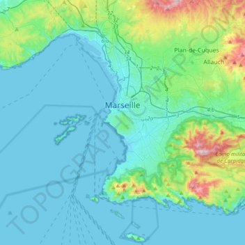
Name: Marseille topographic map, elevation, terrain.
Average elevation: 308 ft
Minimum elevation: -16 ft
Maximum elevation: 2,090 ft
Other topographic maps
Click on a map to view its topography, its elevation and its terrain.
Gémenos
France > Provence-Alpes-Côte d'Azur > Bouches-du-Rhône
Gémenos, Marseille, Bouches-du-Rhône, Provence-Alpes-Côte d'Azur, Metropolitan France, 13420, France
Average elevation: 1,004 ft
Aix-en-Provence
France > Provence-Alpes-Côte d'Azur > Bouches-du-Rhône
Aix-en-Provence, Bouches-du-Rhône, Provence-Alpes-Côte d'Azur, Metropolitan France, France
Average elevation: 886 ft
Mont Puget
France > Provence-Alpes-Côte d'Azur > Bouches-du-Rhône > Marseille
Mont Puget, Marseille, Bouches-du-Rhône, Provence-Alpes-Côte d'Azur, Metropolitan France, 13000, France
Average elevation: 948 ft
Crête de l'Estret
France > Provence-Alpes-Côte d'Azur > Bouches-du-Rhône > Marseille
Crête de l'Estret, 9th Arrondissement, Marseille, Bouches-du-Rhône, Provence-Alpes-Côte d'Azur, Metropolitan France, 13009, France
Average elevation: 1,007 ft
Pélissanne
France > Provence-Alpes-Côte d'Azur > Bouches-du-Rhône
Pélissanne, Aix-en-Provence, Bouches-du-Rhône, Provence-Alpes-Côte d'Azur, Metropolitan France, 13330, France
Average elevation: 381 ft
Salon de Provence
France > Provence-Alpes-Côte d'Azur > Bouches-du-Rhône
Salon de Provence, Aix-en-Provence, Bouches-du-Rhône, Provence-Alpes-Côte d'Azur, Metropolitan France, 13300, France
Average elevation: 390 ft
Saint-Cannat
France > Provence-Alpes-Côte d'Azur > Bouches-du-Rhône
Saint-Cannat, Aix-en-Provence, Bouches-du-Rhône, Provence-Alpes-Côte d'Azur, Metropolitan France, 13760, France
Average elevation: 778 ft
La Merindole
France > Provence-Alpes-Côte d'Azur > Bouches-du-Rhône > Aix-en-Provence
La Merindole, Aix-en-Provence, Bouches-du-Rhône, Provence-Alpes-Côte d'Azur, Metropolitan France, 13545, France
Average elevation: 459 ft
Vernègues
France > Provence-Alpes-Côte d'Azur > Bouches-du-Rhône
Vernègues, Aix-en-Provence, Bouches-du-Rhône, Provence-Alpes-Côte d'Azur, Metropolitan France, 13116, France
Average elevation: 741 ft
Les Aspres
France > Provence-Alpes-Côte d'Azur > Bouches-du-Rhône > Pélissanne
Les Aspres, Pélissanne, Aix-en-Provence, Bouches-du-Rhône, Provence-Alpes-Côte d'Azur, Metropolitan France, 13330, France
Average elevation: 512 ft
Rognes
France > Provence-Alpes-Côte d'Azur > Bouches-du-Rhône
Rognes, Aix-en-Provence, Bouches-du-Rhône, Provence-Alpes-Côte d'Azur, Metropolitan France, 13840, France
Average elevation: 961 ft
Harry Potter
France > Provence-Alpes-Côte d'Azur > Bouches-du-Rhône > Marseille
Harry Potter, 9th Arrondissement, Marseille, Bouches-du-Rhône, Provence-Alpes-Côte d'Azur, Metropolitan France, 13009, France
Average elevation: 361 ft
Lo Val de Cuech
France > Provence-Alpes-Côte d'Azur > Bouches-du-Rhône > Salon de Provence
Lo Val de Cuech, Salon de Provence, Aix-en-Provence, Bouches-du-Rhône, Provence-Alpes-Côte d'Azur, Metropolitan France, 13300, France
Average elevation: 453 ft
Charleval
France > Provence-Alpes-Côte d'Azur > Bouches-du-Rhône
Charleval, Aix-en-Provence, Bouches-du-Rhône, Provence-Alpes-Côte d'Azur, Metropolitan France, 13350, France
Average elevation: 574 ft
Carnoux-en-Provence
France > Provence-Alpes-Côte d'Azur > Bouches-du-Rhône
Carnoux-en-Provence, Marseille, Bouches-du-Rhône, Provence-Alpes-Côte d'Azur, Metropolitan France, 13470, France
Average elevation: 840 ft
Cuges-les-Pins
France > Provence-Alpes-Côte d'Azur > Bouches-du-Rhône
Cuges-les-Pins, Marseille, Bouches-du-Rhône, Provence-Alpes-Côte d'Azur, Metropolitan France, 13780, France
Average elevation: 1,529 ft
Le Redon
France > Provence-Alpes-Côte d'Azur > Bouches-du-Rhône > Marseille
Le Redon, 9th Arrondissement, Marseille, Bouches-du-Rhône, Provence-Alpes-Côte d'Azur, Metropolitan France, 13009, France
Average elevation: 476 ft
Montredon
France > Provence-Alpes-Côte d'Azur > Bouches-du-Rhône > Marseille
Montredon, 8th Arrondissement, Marseille, Bouches-du-Rhône, Provence-Alpes-Côte d'Azur, Metropolitan France, 13008, France
Average elevation: 289 ft
Frioul Islands
France > Provence-Alpes-Côte d'Azur > Bouches-du-Rhône > Marseille
Frioul Islands, 7th Arrondissement, Marseille, Bouches-du-Rhône, Provence-Alpes-Côte d'Azur, Metropolitan France, 13007, France
Average elevation: 10 ft
Eyguières
France > Provence-Alpes-Côte d'Azur > Bouches-du-Rhône
Eyguières, Aix-en-Provence, Bouches-du-Rhône, Provence-Alpes-Côte d'Azur, Metropolitan France, 13430, France
Average elevation: 440 ft
La Ciotat
France > Provence-Alpes-Côte d'Azur > Bouches-du-Rhône > La Ciotat > La Ciotat
La Ciotat, Marseille, Bouches-du-Rhône, Provence-Alpes-Côte d'Azur, Metropolitan France, 13600, France
Average elevation: 187 ft
Maussane-les-Alpilles
France > Provence-Alpes-Côte d'Azur > Bouches-du-Rhône
Maussane-les-Alpilles, Arles, Bouches-du-Rhône, Provence-Alpes-Côte d'Azur, Metropolitan France, 13520, France
Average elevation: 217 ft
Port-de-Bouc
France > Provence-Alpes-Côte d'Azur > Bouches-du-Rhône > Port-de-Bouc > Port-de-Bouc
Port-de-Bouc, Istres, Bouches-du-Rhône, Provence-Alpes-Côte d'Azur, Metropolitan France, 13110, France
Average elevation: 39 ft
Orgon
France > Provence-Alpes-Côte d'Azur > Bouches-du-Rhône
Orgon, Arles, Bouches-du-Rhône, Provence-Alpes-Côte d'Azur, Metropolitan France, 13660, France
Average elevation: 410 ft
Carry-le-Rouet
France > Provence-Alpes-Côte d'Azur > Bouches-du-Rhône
Carry-le-Rouet, Istres, Bouches-du-Rhône, Provence-Alpes-Côte d'Azur, Metropolitan France, 13620, France
Average elevation: 302 ft
Martigues
France > Provence-Alpes-Côte d'Azur > Bouches-du-Rhône
Martigues, Istres, Bouches-du-Rhône, Provence-Alpes-Côte d'Azur, Metropolitan France, France
Average elevation: 115 ft
Lambesc
France > Provence-Alpes-Côte d'Azur > Bouches-du-Rhône
Lambesc, Aix-en-Provence, Bouches-du-Rhône, Provence-Alpes-Côte d'Azur, Metropolitan France, 13410, France
Average elevation: 764 ft
Fontvieille
France > Provence-Alpes-Côte d'Azur > Bouches-du-Rhône
Fontvieille, Arles, Bouches-du-Rhône, Provence-Alpes-Côte d'Azur, Metropolitan France, 13990, France
Average elevation: 125 ft
Aubagne
France > Provence-Alpes-Côte d'Azur > Bouches-du-Rhône
Aubagne, Marseille, Bouches-du-Rhône, Provence-Alpes-Côte d'Azur, Metropolitan France, 13400, France
Average elevation: 719 ft
Istres
France > Provence-Alpes-Côte d'Azur > Bouches-du-Rhône
Istres, Bouches-du-Rhône, Provence-Alpes-Côte d'Azur, Metropolitan France, France
Average elevation: 108 ft
Saint-Rémy-de-Provence
France > Provence-Alpes-Côte d'Azur > Bouches-du-Rhône
Saint-Rémy-de-Provence, Arles, Bouches-du-Rhône, Provence-Alpes-Côte d'Azur, Metropolitan France, 13210, France
Average elevation: 328 ft
Fos-sur-Mer
France > Provence-Alpes-Côte d'Azur > Bouches-du-Rhône
Fos-sur-Mer, Istres, Bouches-du-Rhône, Provence-Alpes-Côte d'Azur, Metropolitan France, 13270, France
Average elevation: 33 ft
Le Puy-Sainte-Réparade
France > Provence-Alpes-Côte d'Azur > Bouches-du-Rhône
Le Puy-Sainte-Réparade, Aix-en-Provence, Bouches-du-Rhône, Provence-Alpes-Côte d'Azur, Metropolitan France, 13610, France
Average elevation: 896 ft
Gardanne
France > Provence-Alpes-Côte d'Azur > Bouches-du-Rhône
Gardanne, Aix-en-Provence, Bouches-du-Rhône, Provence-Alpes-Côte d'Azur, Metropolitan France, 13120, France
Average elevation: 837 ft
Port-Saint-Louis-du-Rhône
France > Provence-Alpes-Côte d'Azur > Bouches-du-Rhône
Port-Saint-Louis-du-Rhône, Istres, Bouches-du-Rhône, Provence-Alpes-Côte d'Azur, Metropolitan France, 13230, France
Average elevation: 0 ft
Trets
France > Provence-Alpes-Côte d'Azur > Bouches-du-Rhône
Trets, Aix-en-Provence, Bouches-du-Rhône, Provence-Alpes-Côte d'Azur, Metropolitan France, 13530, France
Average elevation: 1,145 ft
Port-de-Bouc
France > Provence-Alpes-Côte d'Azur > Bouches-du-Rhône
Port-de-Bouc, Istres, Bouches-du-Rhône, Provence-Alpes-Côte d'Azur, Metropolitan France, 13110, France
Average elevation: 39 ft