
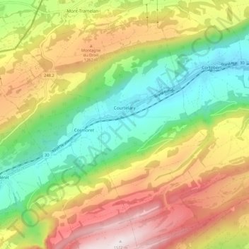
Courtelary topographic map
Interactive map
Click on the map to display elevation.
About this map
Name: Courtelary topographic map, elevation, terrain.
Average elevation: 3,474 ft
Minimum elevation: 2,201 ft
Maximum elevation: 5,154 ft
Other topographic maps
Click on a map to view its topography, its elevation and its terrain.
Orvin
Switzerland > Bern > Bernese Jura administrative district
Orvin, Bernese Jura administrative district, Bernese Jura administrative region, Bern, 2534, Switzerland
Average elevation: 2,628 ft
Villeret
Switzerland > Bern > Bernese Jura administrative district
Villeret, Bernese Jura administrative district, Bernese Jura administrative region, Bern, 2613, Switzerland
Average elevation: 3,556 ft