
Hwange topographic map
Interactive map
Click on the map to display elevation.
About this map
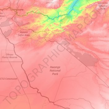
Name: Hwange topographic map, elevation, terrain.
Location: Hwange, Matabeleland North, 00236, Zimbabwe (-19.88950 25.23730 -17.79137 27.75694)
Average elevation: 3,176 ft
Minimum elevation: 1,572 ft
Maximum elevation: 4,377 ft
Other topographic maps
Click on a map to view its topography, its elevation and its terrain.
Victoria Falls
Zimbabwe > Matabeleland North > Hwange > Victoria Falls
Victoria Falls, Hwange, Matabeleland North, 00236, Zimbabwe
Average elevation: 2,900 ft