
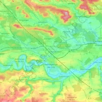
Vaihingen an der Enz topographic map
Interactive map
Click on the map to display elevation.
About this map
Name: Vaihingen an der Enz topographic map, elevation, terrain.
Average elevation: 928 ft
Minimum elevation: 617 ft
Maximum elevation: 1,558 ft
At the top of the town is since 1256 the mayor and the court, consisting of twelve citizens, including four mayors. Chairman of the court was the official mayor. With the elevation to Große Kreisstadt on January 1, 1973, the mayor bears the official title Lord mayor. He is directly elected by the electorate every 8 years. He is chairman of the municipal council. His general deputy is the first councilor with the official title of mayor.