Vic-sur-Cère topographic map
Interactive map
Click on the map to display elevation.
About this map
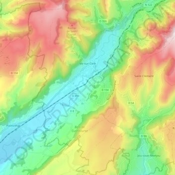
Name: Vic-sur-Cère topographic map, elevation, terrain.
Average elevation: 2,995 ft
Minimum elevation: 2,067 ft
Maximum elevation: 4,304 ft

Click on the map to display elevation.
Name: Vic-sur-Cère topographic map, elevation, terrain.
Average elevation: 2,995 ft
Minimum elevation: 2,067 ft
Maximum elevation: 4,304 ft