
Parque Nacional Waraira Repano topographic map
Interactive map
Click on the map to display elevation.
About this map
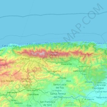
Name: Parque Nacional Waraira Repano topographic map, elevation, terrain.
Average elevation: 1,280 ft
Minimum elevation: 0 ft
Maximum elevation: 8,963 ft
Other topographic maps
Click on a map to view its topography, its elevation and its terrain.
Guarenas
Venezuela > Estado Miranda > Municipio Plaza
Guarenas, Parroquia Guarenas, Municipio Plaza, Estado Miranda, 1220, Venezuela
Average elevation: 2,310 ft