
Seesen topographic map
Interactive map
Click on the map to display elevation.
About this map
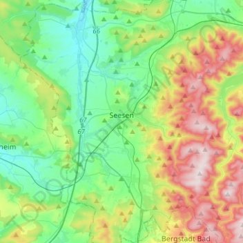
Name: Seesen topographic map, elevation, terrain.
Location: Seesen, Landkreis Goslar, Lower Saxony, 38723, Germany (51.80905 10.06569 51.96351 10.22238)
Average elevation: 922 ft
Minimum elevation: 400 ft
Maximum elevation: 2,018 ft
Other topographic maps
Click on a map to view its topography, its elevation and its terrain.
Harz (LK Goslar)
Germany > Lower Saxony > Landkreis Goslar
Harz (LK Goslar), Landkreis Goslar, Lower Saxony, Germany
Average elevation: 1,457 ft
Goslar
Germany > Lower Saxony > Landkreis Goslar
Goslar, Landkreis Goslar, Lower Saxony, Germany
Average elevation: 1,024 ft