
St Helens topographic map
Interactive map
Click on the map to display elevation.
About this map
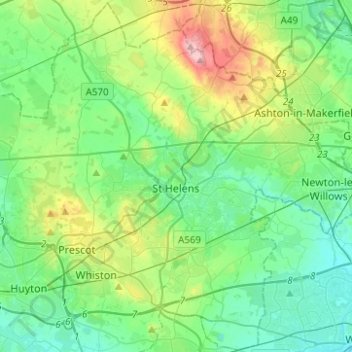
Name: St Helens topographic map, elevation, terrain.
Location: St Helens, North West England, England, United Kingdom (53.38537 -2.82504 53.53141 -2.57663)
Average elevation: 161 ft
Minimum elevation: 20 ft
Maximum elevation: 574 ft
Other topographic maps
Click on a map to view its topography, its elevation and its terrain.
Billinge
United Kingdom > England > St Helens
Billinge, St Helens, Liverpool City Region, England, WN5 7LZ, United Kingdom
Average elevation: 308 ft
Rainford Junction
United Kingdom > England > St Helens
Rainford Junction, Rainford, St Helens, Liverpool City Region, England, WA11 7JT, United Kingdom
Average elevation: 194 ft