
Buchs (SG) topographic map
Interactive map
Click on the map to display elevation.
About this map
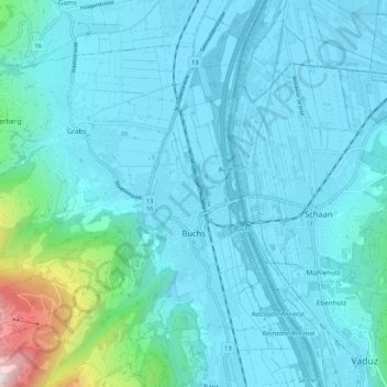
Name: Buchs (SG) topographic map, elevation, terrain.
Location: Buchs (SG), Wahlkreis Werdenberg, St. Gallen, Switzerland (47.13703 9.39773 47.20304 9.50265)
Average elevation: 1,890 ft
Minimum elevation: 1,430 ft
Maximum elevation: 5,627 ft
Other topographic maps
Click on a map to view its topography, its elevation and its terrain.
Trübbach
Switzerland > St. Gallen > Wahlkreis Werdenberg > Wartau
Trübbach, Wartau, Wahlkreis Werdenberg, St. Gallen, 9477, Switzerland
Average elevation: 1,860 ft
Grabs
Switzerland > St. Gallen > Wahlkreis Werdenberg > Grabs
Grabs, Wahlkreis Werdenberg, St. Gallen, 9472, Switzerland
Average elevation: 3,005 ft