
Towson topographic map
Interactive map
Click on the map to display elevation.
About this map
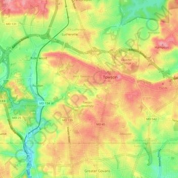
Name: Towson topographic map, elevation, terrain.
Location: Towson, Baltimore County, Maryland, United States (39.37199 -76.66714 39.42101 -76.56303)
Average elevation: 374 ft
Minimum elevation: 184 ft
Maximum elevation: 551 ft
Other topographic maps
Click on a map to view its topography, its elevation and its terrain.
Hydes
United States > Maryland > Baltimore County > Towson
Hydes, Towson, Baltimore County, Maryland, 21013, United States
Average elevation: 404 ft
Brooklandville
United States > Maryland > Baltimore County > Towson
Brooklandville, Towson, Baltimore County, Maryland, 21022, United States
Average elevation: 400 ft
Rockland
United States > Maryland > Baltimore County > Towson
Rockland, Towson, Baltimore County, Maryland, 21022, United States
Average elevation: 351 ft
Long Green
United States > Maryland > Baltimore County > Towson
Long Green, Towson, Baltimore County, Maryland, 21057, United States
Average elevation: 423 ft
Greenwood
United States > Maryland > Baltimore County > Towson
Greenwood, Towson, Baltimore County, Maryland, 21057, United States
Average elevation: 305 ft
Glen Arm
United States > Maryland > Baltimore County > Towson
Glen Arm, Towson, Baltimore County, Maryland, 21057, United States
Average elevation: 358 ft