
District 1 topographic map
Interactive map
Click on the map to display elevation.
About this map
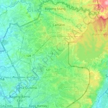
Name: District 1 topographic map, elevation, terrain.
Average elevation: 171 ft
Minimum elevation: 10 ft
Maximum elevation: 623 ft
Other topographic maps
Click on a map to view its topography, its elevation and its terrain.
Barangay 161
Barangay 161, Zone 14, Libis Baesa/Reparo, District 1, Caloocan, Northern Manila District, Metro Manila, 1401, Philippines
Average elevation: 72 ft